Day 14 – Another rainy day
We’ve decided to pack up and move down to Calgary today as it is another cold, rainy day. Our flight is tomorrow morning at 8 a.m. and since the rain is forecasted to change to snow, we feel it is best to do the drive today.
All is not lost though, since today is the opening day for the Calgary Home Design Show sponsored by HGTV and we will be enjoying that rainy day activity.
This is our last post and we hope you have enjoyed our Canadian Rockies adventure. We (Steve) are already talking about returning to this most beautiful area next year. Please let us know if you enjoyed our blog.
Rene and Steve
Thursday, September 16, 2010
Day 13 - Johnston Canyon and the Ink Pots

Day 13 - Johnston Canyon and the Ink Pots
Even though we did a long hike yesterday, Steve insisted that we hike today since the weather was beautiful. We decided on what is the most popular hike in the Canadian Rockies – Johnston Canyon with its numerous waterfalls.
The path along the canyon is actually paved with numerous catwalks overhanging the turbulent waters of Johnston Creek and the waterfalls. The lower falls is reached at km 1.1. A bridge across the creek serves as a viewpoint thundering cataract, and a short tunnel through the bedrock allows passage to a more intimate vantage point. Back on the trail there are numerous waterfalls (bigger than any in Michigan) before reaching the Upper Falls at km 2.7

The Upper Falls is 30m (98 feet) and there are two viewpoints: one from a catwalk at the bottom; and the other after a short steep hike to the upper part of the falls. You have a beautiful view of the gorge and the falls from the upper viewpoint.
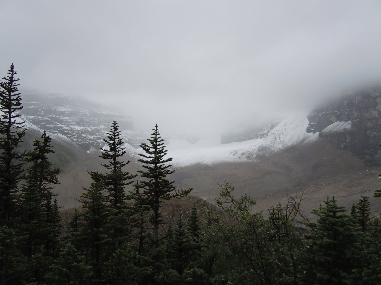
We continued from here another 3km to the Inkpots. The trail here is unpaved and very few people continue past the Upper Falls. The trail ascends steeply through the forest and then down again into the valley where the inkpots reside. The inkpots are seven cold mineral springs bubbling to the surface in the open meadow. The springs are unique as they are 4ºC year round and the bottoms are composed of quicksand.

It was here we stopped for lunch and enjoyed the panoramic view of the valley and the surrounding snow capped mountains.
We could see snow falling on the distant mountains and by the time we left the Inkpots it was raining lightly. We enjoyed the hike back to the car where the sun was again shinning.

Day 12 - Yoho National Park Twin Falls Hike


Day 12- Hiking in the Yoho National Park to Twin Falls
Sorry for the delay in updates in our blog, the internet is a little sporadic where we are staying this week. Yesterday we decided to drive back to the Yoho National Park and hike a different trail. We started at the Takakkaw Falls parking lot to the Yoho Valley Road trailhead. The trail meanders along the Yoho River through plains and then through the forest past Angel’s staircase, Point Lace Falls, and Laughing falls. The trail as far as Laughing Falls is very easy and the falls is a must see.

We reached Twin Falls and the tea house, our destination, in about 3 hours. Unfortunately the tea house was already closed for the season.
The trail was originally cut by a Canadian Pacific Railroad trail crew in 1901. The Twin Falls Chalet (tea house) was constructed by the CPR in 1923 and first opened for business the following year. The rustic Swiss-style log building has been operated by Fran Drummond of Calgary since 1962. We checked out the rates and it is $250 a night per person, minimum two nights stay, although it was nice I’m not sure the absence of running water, outdoor toilet facilities, and glorified cots were worth the price.

Twin Falls is formed by a stream from Glacier des Poilus, which splits into two branches just above the precipice. The left fall occasionally dwindles down to a trickle or shuts off altogether when an obstruction blocked the channel. In the past the CPR employees were dispatched to the lip of the falls to correct the problem with dynamite. I don’t think they have been there lately since the left fall was not flowing.

The view was spectacular and a wonderful place to stop and have lunch. Pictures will not do it justice. It was like sitting in this majestic canyon with the sun glistening on the rock walls and trees with the sound of the water falling and hitting the floor of the canyon. The Whaleback mountain towered above us in the background. It was so peaceful and well worth the climb.
We took a different trail back to the car past Marpole Lake and a massive boulder field. The cliffs and overhangs above us were massive with beautiful colors intermixed in the rocks.

Total trip time 6 hours, elevation gain 950ft, Maximum elevation 5,900 ft, total miles traveled 16.4 kms (10.2 miles.
Monday, September 13, 2010
Day 11 -Rain, rain and more rain
Rain, rain, go away; come back after Rene and Steve leave.
That’s the story for today. Rain all day. Visited the hot tub and pool at the resort, read, and Steve prepared for a new consulting assignment that starts next Monday.
Tomorrow we plan to hike to Twin Falls in the Yoho Valley, weather allowing.
That’s the story for today. Rain all day. Visited the hot tub and pool at the resort, read, and Steve prepared for a new consulting assignment that starts next Monday.
Tomorrow we plan to hike to Twin Falls in the Yoho Valley, weather allowing.
Sunday, September 12, 2010
Day 10- Horseback riding in Lake Louise

Today rain was predicted and it was our rest day from hiking so we decided to book a horseback riding trip at Lake Louise. Prediction came true, it rained the entire day we were on horseback. We did the mountain trail ride to the Plain of Six Glaciers. We traveled by horseback to the end of Lake Louise and to the base of Victoria Glacier where you can view numerous glacial fields and Mount Victoria (on a clear day that is). The ride continued beneath spectacular rock face and though sub alpine forest and across large avalanche paths along the slopes of Mount Whyte. We next traveled to a viewpoint where the ‘plain’ can be viewed. This is a long glacier at the base of the lower Victoria Glacier.

We viewed six other glaciers (through the fog, rain, and snow) including Lower Victoria, Aberdeen, Lefory, Upper Lefroy and Popes. The last leg of the trip (upward) was to the Plain of Six Glacier Tea House, built in 1924, at 7000 feet as a base for Swiss Guide Mountaineers. A much needed Hot chocolate was waiting for us. I regret not putting the Baileys in our packs…
The way down the mountain was much more challenging since it was wetter and steeper than on the way up (go figure). Steve was awesome on his horse “Trigger” (I guess all those years at camp paid off), I was a little scared at the steepest points on my horse “Traveler” but made it down the mountain safe and sound (I don’t think the Old Circle T horse stables in Oxford back in the day was the greatest training ground for this ride).
Picture taking was minimal since I was holding on to the reins and the horn of the saddle for dear life. The trip was awesome despite the rain and cold, our only regret is not wearing bike shorts……
Saturday, September 11, 2010
Day 9- Stanley Glacier hike and Minnewanka Lake drive

Day 9- Stanley Glacier hike and Minnewanka Lake drive
Today we drove to British Columbia in the Kootnay National Park and hiked up to the Stanley Glacier. The start was a little iffy, when we reached the trail head it was pouring rain and there was a special sign posted on the trail map that there were bears in the area. As you all know sugar melts, so the rain was the first strike against this hike and secondly the glaring bear sign scared me to death. Steve on the other hand was ready to rock and roll, thinks his singing and his bear spray would keep us safe….. Anyway after the rain stopped and major arm twisting we started the hike.
This particular valley was shaped by fire- 1968 Vermillion Pass burn which charred 2,500 hectares of forest. We began the trek across the Vermillion River into the forest of predominantly lodgepole pine, a lot of which, remains charred. We followed the switchbacks (singing and yelping all the way) to Stanley creek and beautiful views of the eastern flank of Stanley Peak. From here we were also able to see Banff’s Castle Mountain to the north, with Mount Whymper and Boom Mountain directly behind us to the Northwest. As we climbed a little higher we had a great view of Storm Mountain to the East.
We continued upward to where the trail flattened out and we entered the hanging valley. Once there the trail remains fairly level across Stanley Creek, where it parallels the sheer 450-meter Cambrian limestone wall of Stanley Peak. We were able to see a few waterfalls cascading over the edge of the face; and the caves just past the boulder field. This is were we stopped to have lunch; which needed to be guarded against the golden-mantled ground squirrels, marmots, and pikas that live in the boulders. The climb continued about 900 meter to the plateau of the glacier. Fairly easy hike and we did not see any bears this trip. Total Distance: 9.6 kilometers, Hiking time: 3.5 hours, Elevation gain 365 meters.

Following our hike we took a different way back to our chalet via the 1A highway. It was a beautiful drive through the forests of Banff National Park. We then took the drive through Minnewanka Lake and Two Jack Lake.

Batteries charged on both cameras so lots of pictures, unfortunately the internet service where we are staying is very slow so pictures will be minimal. Our adventure continues and we hope you are enjoying it as much as we are.
Friday, September 10, 2010
Day 8 Moving day
Today we moved from downtown Canmore to a resort that is in the mountains in Dead Man's flats... I sure hope there is no meaning behind this. We have more of a cabin (chalet) than a condo this time. It's a little older and further out from town, but it's clean a roomy and has beautiful views of the mountains. We had lunch in Canmore sitting outside with the sun on our faces. Lovely day.
This afternoon we chilled and enjoyed a cocktail while taking in the mountain scenery.


This afternoon we chilled and enjoyed a cocktail while taking in the mountain scenery.


Day 7- Hiking in British Columbia Yoho National Park
Day 7- Hiking in British Columbia Yoho National Park
Today we drove to British Columbia and the Yoho National Park to hike one of the many trials available. A little history: the Yoho Valley wasn’t explored until 1897 when the German alpinist Jean Habel reached the valley from Emerald Lake via Yoho Pass. Habel reported on the valley’s exceptional features which included an impressive array of glaciated peaks, extensive icefields, and stunning waterfalls including the stunning 254-m Takakkaw Falls.
Edward Whymper, conqueror of Switzerland’s Matterhorn, explored the region for the Canandian Pacific Railway in 1901. Though he was 61 years old, he climbed and hiked throughout the Yoho Valley area, photographing all the major mountains and valleys. From his long experience in Europe, he saw the recreational potential of the Yoho and recommended the construction of several trails.
One of which is called the Iceline Trail¸ this is the one we chose to do. It was absolutely amazing! The only problem was at the start of the hike I experienced my worst nightmare the words “battery exhausted” on my camera and no backup. (lots of backup sitting in our condo) We ended up taking a few pictures on Steve’s cell phone but don’t have the means to transfer them to the blog at this time, so just a narrative at this time. I hope I do it justice. This trail was about an hour and a half from our condo in Canmore.
Our hike began just past the Takakkaw Falls (290 meter water freefall, one of the highest in Canada) through the campground to the Yoho River trail. We hiked along the river before heading up through the forest, passing the beautiful Laughing Falls. If we had the time we could have sat here all day watching the beautiful falls. From here we continued to climb until we met the junction of the Iceline trail passing numerous streams and waterfalls. This junction was at 6.7km. Before reaching the junction, we stopped for lunch before crossing a bridge over a tributary of the Yoho River. It was very a romantic, beautiful spot, very majestic. After lunch we continued to climb through the forest through wildflower meadows until we reached an open meadow and the views of incredible glaciers in front and to the side of us. A completely different terrain than where we have been so far. We arrive at the Iceline trail junction high on the open avalanche slopes of the Presidential Range. This is where the real glories of the Iceline begin as it climbs over the terminal and ground moraines of the Emerald and other Glaciers. The glaciers are a constant companion above the trail, with small waterfalls, and a few small ice breaks (avalanches) above us. Once through this area we begin our descent and can see the Takakkaw Falls in the distant. It was a beautiful hike and one we will never forget. Total kms traveled 17 (over 10 miles), elevation gain 2,250 ft, maximum elevation 7,250 ft. Time of hike including stops was 6 and a half hours.
p.s. Rene still worried about bears. We sang and went through the entire alphabet: Taking a hike: bringing A apple; B bear; C camera (with a fully charged battery); D dog (to protect us from the bear); E elephant (to make noise so the bear knows we’re coming); F Frank; G good and plenty’s; H Harry (a group of four is safer from bears than a group of two; I ibuprofen; etc, etc. You get the idea..
Wednesday, September 8, 2010
Day 6 - Alberta Canada
Today was a very rainy day so no hiking. We spent the morning doing laundry and reading. This afternoon we went to the Banff Hot Springs (kinda a huge hot tub but felt good) and then to Pleiades Spa for much needed massages. In my book this was a great day. Tomorrow is suppose to be a nice day so we are planning on hiking. Will post more pictures tomorrow (that's if I don't get eaten by any grizzles).....
Tuesday, September 7, 2010
Day 5 - Exploring Banff
Day 5- Exploring Banff
Today we decided to do a little sightseeing around the Banff area, about 20 minutes from where we are staying.
History of Banff:
Banff (pronounced "Bamph") is located in the center of Banff National Park, surrounded on all sides by Alberta's Rocky Mountains. At 4540 feet (1384 m) above sea level, Banff is "Canada's Highest Town". Banff is 90 miles (144 km) from Calgary and just a short trip to the mountain areas of Lake Louise, Kananaskis Country and Canmore.
1883 was the year that the transcontinental railway reached the formidable Rocky Mountains. One day while three railway workers were hiking, they came upon some simmering natural hot springs bubbling from the base of Sulphur Mountain.
The area was protected by the government and two years later became Canada's first national park, Rocky Mountain Park. Banff, town and park, are named for Banffshire, Scotland – the birthplace of two of the original Canadian Pacific Railway directors.
We started our day off at the visitor’s center to pick up the “official” map of town, its sites, and walking tour routes. We then headed off on foot through town and ended up on the Bow River Fall’s trail. The river was beautiful with mountain vistas in the background and the Falls at the end of the trail.
Along the way we were able to see the historic Banff Spring Hotel from the trail. This hotel is among the largest and most renowned of the fashionable resort hotels established along railway and steamship routes in Canada during the late 19th and early 20th centuries. Constructed by the Canadian Pacific Railway Co. in stages between 1911 &1928, the hotel developed an international reputation for excellence as a vacation retreat and became a symbol of the significance of tourism in the Canadian Rockies. Its striking natural setting, Chateau style design and plush interior décor appealed to a wealthy clientele.
We then headed back to town and did the rest of the tour by car via Tunnel Mountain Rd. Most of the road was winding and through the woods. We ran into a herd of Elk crossing the road, we couldn’t believe the size of the rack on the male. It was awesome seeing the Elk and thrilled that I was able to get a few photos of them.
We then headed further East up to the “Hoodoos”. It’s a strange word for strangely shaped rock pillars.
Another great day!
Today we decided to do a little sightseeing around the Banff area, about 20 minutes from where we are staying.
History of Banff:
Banff (pronounced "Bamph") is located in the center of Banff National Park, surrounded on all sides by Alberta's Rocky Mountains. At 4540 feet (1384 m) above sea level, Banff is "Canada's Highest Town". Banff is 90 miles (144 km) from Calgary and just a short trip to the mountain areas of Lake Louise, Kananaskis Country and Canmore.
1883 was the year that the transcontinental railway reached the formidable Rocky Mountains. One day while three railway workers were hiking, they came upon some simmering natural hot springs bubbling from the base of Sulphur Mountain.
The area was protected by the government and two years later became Canada's first national park, Rocky Mountain Park. Banff, town and park, are named for Banffshire, Scotland – the birthplace of two of the original Canadian Pacific Railway directors.
We started our day off at the visitor’s center to pick up the “official” map of town, its sites, and walking tour routes. We then headed off on foot through town and ended up on the Bow River Fall’s trail. The river was beautiful with mountain vistas in the background and the Falls at the end of the trail.

Along the way we were able to see the historic Banff Spring Hotel from the trail. This hotel is among the largest and most renowned of the fashionable resort hotels established along railway and steamship routes in Canada during the late 19th and early 20th centuries. Constructed by the Canadian Pacific Railway Co. in stages between 1911 &1928, the hotel developed an international reputation for excellence as a vacation retreat and became a symbol of the significance of tourism in the Canadian Rockies. Its striking natural setting, Chateau style design and plush interior décor appealed to a wealthy clientele.

We then headed back to town and did the rest of the tour by car via Tunnel Mountain Rd. Most of the road was winding and through the woods. We ran into a herd of Elk crossing the road, we couldn’t believe the size of the rack on the male. It was awesome seeing the Elk and thrilled that I was able to get a few photos of them.

We then headed further East up to the “Hoodoos”. It’s a strange word for strangely shaped rock pillars.

Another great day!
Day 4- Columbia Icefield and Athabasca Glacier

Day 4 in Alberta
Today we drove to the Columbia Icefields and the Athabasca Glacier via the Icefields Parkway. For the most part, the Parkway is an easy drive with views of peaks and glaciers along the way. It was a little cloudy but we were able to see Mount Hector, at 11,100 feet, spectacular. It took us about 2 ½ hours to actually reach the Icefields with stops along the way for picture taking, took more time for this on the way home. By the way we saw another bear today eating berries on the side of the road.
A little history and facts about the Icefields and Glaciers: The Athabasca Glacier and the Columbia Icefield once formed part of an enormous ice sheet that ground and carved the landforms that you see today throughout the Rocky Mountains. An alpine icefield is formed when snow that falls on high mountain peaks and plateaus accumulates year after year with little summer melt. When the snow attains a depth of about 30 meters (100 ft.), the bottom layers become pressurized into ice. More snow falls on top and the depth of ice increases, eventually overflowing into the surrounding valleys and starts flowing downhill- a glacier is born! We took the snowcoach out to the headwall of the Athabasca Glacier and walked around on it. The part we were standing on was as thick as the Eiffel Tower is tall (ranges from 270ft to 1000ft in depth and 3.75 miles in length).

Our next stop was the Parker Ridge Trail head where we hiked up to the Parker Ridge Pass Crest (7400 ft ridge crest) where we were able to see the Saskatchewan Glacier as well as the summits backing the Athabasca Glacier. It was a little cold and windy up there and started snowing but the views were still spectacular.

We then ventured onward to Peyto Lake. After a short hike to the viewing platform we could see the turquoise expanse of Peyto Lake and its ring of craggy grey summits. To the north we could see a beautiful U-shaped valley of the Mistaya River.

We then drove to Bow Lake with the intent on hiking to Bow Glacier Falls, however, it was getting late in the day and we spotted this really beautiful lodge further down the trail. The lodge is the Historic Num-Ti-Jah Lodge, what a find. We decided to go in the lodge and ended up staying for dinner. What a treat! The food, the service, and the atmosphere were outstanding. This one for sure will be rated high in our travel book.


Sunday, September 5, 2010
Day 3- Drive through Peter Lougheed Park and Kananaskis Recreation Area

Day 3 in Alberta
It snowed last night in the mountains leaving Canmore’s mountains covered in snow. The hike we did yesterday would most likely be impossible because of the amount of snow that fell last night. We were too sore to do much of anything today although we did managed to hobble into town this morning in light rain, looked in the stores and had lunch.

In the afternoon we took a long drive through the Peter Lougheed Provincial Park and Kananaskis Country Recreation Area. You are surrounded at all times by snow covered mountains and beautiful lakes and streams. We passed by a campground and Rene said she wouldn’t stay at a campground because of the bears. I was about to tell her there probably aren’t any bears around when in the road 150 yards ahead of us a grizzly is crossing. Rene managed to get the camera on and snap a shot before he disappeared in the woods. Rene’s apprehension grows stronger daily about encountering those grizzles on the trails. I guess we need to sing a little louder.

On the drive on the way back we stopped at Kananaskis Village. It’s a beautiful Resort with lots of activities. We inquired about bike rentals there and were told the trails have been closed for over a month due to bear activity; they are feeding on the berry bushes just off the trail. I guess they are getting ready for hibernation.
Tomorrow’s plans up still up in the air, all depends on our legs and whether they can handle the next hike. Mostly likely we will be going to the Columbia Ice fields instead.
Day 2 - Hiking in Lake Louise


Day 2 Hiking in Lake Louise
Today we drove to Lake Louise about 81kms (1km = .62miles) from Canmore. We had to purchase a park pass on the way which ran $20 per day or $138 dollars for a year pass. Needless to say we did the math and we are now the proud owners of a pass to all Canadian parks for a year. We reached the parking lot of the famous Fairmount Hotel at about 9:00 am. It was about 40º with a little light rain, and snow. This was supposed to be the nicest day of the week. We decided to hike the Saddleback Loop. The Saddleback circuit takes you from Lake Louise to a scenic pass studded with majestic alpine larches, and then down through Sheol Valley to Paradise Valley, returning to Lake Louise by a forested trail.
After taking in the spectacular views of Lake Louise, and a few pictures, we started our hike and found the trail for Saddleback; it’s just to the left of the entrance to the Fairmount canoe rental path. The trail to the Saddleback is 3.5 km and has an elevation gain of 600 m. The trail goes through some avalanche paths, forested areas and open meadows. About 3 km later with many switchbacks and elevation gain we reached the Saddleback junction from here you can go left onto the Sheol Valley Trail that leads to Paradise valley or right to Fairview Mountain. Our intention from the beginning was to go on to the Sheol Valley trail; however, we came upon a sign at the split that prohibited from hiking in some areas due to grizzly activity.
The sign read: By law, you can only hike in a tightly packed group of four or more. Fine for violation $5000 (not to mention being mauled).
Moral of the story here….
Don’t Leave Home without it……Bear Spray that is! We were the only ones on the trail today without bear spray. We figured the area was so heavily traveled there would be no bears. Big mistake! We will not hike without it again.
What to do, the trail to Fairview Mountain is not clearly defined. The trail is full of switchbacks up a steep slope made up of loose scree. The 1.5 km trail gains an elevation of 444 m. At the summit, you will be 1 km above Lake Louise and have great views of Mt. Temple and Mt Victoria. It looked so big and so hard to climb we weren’t going to do it. FYI- This Mountain is also nicknamed "Overtime Mountain". Many people try to scramble down the northeast side as a shortcut on the way back. This is a sure way to spend the night on a ridge and be billed for a rescue the next morning.
A few kms back on the trail we had stopped to talk to a group of hikers from Calgary, nice group, and after exchanging picture taking we went on our way. They reached the junction just after us (they were smarter and took a break just before reaching us). They talked with us about the bears in Paradise Valley, bear spray must have, and the fine that we will for sure get if we take that route. They encouraged us to climb the Fairview Mountain with them. The last part of the trail has a 30% grade which means for every 100 feet you travel horizontally, you gain 30 feet vertically. It was very steep, breathless going up, sliding on scree on the way down.
We did it, we made it, and the views were worth every ounce of pain we will feel in the morning. Thank you Canadians for your encouragement!


Total mileage roundtrip: 10km or 6.1 miles (felt like 100, miles or km, you pick)
Total elevation gain: 1044 meters or 3425 feet, Total meters above sea level: 2745 or 9006 ft
Total time roundtrip: 5 hours including a half hour at the top, eating lunch and many stops to catch our breath.
Day 1 - Arrival in Canmore, Alberta Canada
We arrived in Calagary on Friday afternoon and drove to Canmore just outside of Baniff where we checked into our condo for the week. Our accommodations are very nice and the views are spectacular. Friday night we explored the town a little bit before heading to dinner at a nice microbrewery pub in town called the “Grizzly Paw”, very appropriate as you read on to day two of our blog. As always it’s a great way to start off an adventure.
Canmore is the cutest town that has a little history. Once part of a giant inland sea, the sedimentary rock along the western edge of Alberta began to form part of the chain of Mountains which eventually became called Rockies about 45 million years ago. Some of Alberta's earliest archaeological sites occur around Canmore and Banff including the 10,000 year old Vermilion Lakes site in Banff and Sibbald Flats located east of Canmore in Kananaskis.
Canmore was named in 1884 by Donald A. Smith, an employee of the Canadian Pacific Railway. The name originates from a town on the northwest shores of Scotland named in honor of King Malcolm III of Canmore. The anglicized version of the Gaelic Ceann Mór , Canmore has been variously translated as "big head" or, more likely, "great head" or "chief".
In 1886 Queen Victoria granted a coal mining charter to the town and in 1887 the first mine was opened.
The North West Mounted Police built their first barracks in Canmore in 1890. It was vacated in 1929 and turned into a private residence. Later, in 1989 the barracks was purchased back by the town and restored.
Through the early 20th century many of the coal mines in the Bow Valley began to shut down. The nearby towns of Anthracite, Georgetown and Bankhead closed down and many of the buildings and residents were relocated to Banff and Canmore. In 1965, Canmore was incorporated as a town with 2,000 residents.
RECENT HISTORY
July 13th, 1979 marked the end of an era when Canmore Mines Ltd. closed their doors. One hundred and twenty miners were out of work. Many of the families of these miners remain in Canmore as evidenced by the annual Miners’ Parade. They have witnessed tremendous change in the town and its people. Of the mines themselves only the Lamp House and a few mine entrances remain due to provincial safety and reclamation policies.
The announcement in the early 1980's that the 1988 Olympic Winter Games would be held in Calgary and Canmore heralded a new era for the town of Canmore. It would be the site of the Nordic events; welcome news for a small community struggling to stay alive. Since the Olympics, Canmore has more than tripled its population and become a vibrant recreational tourism based community.
Subscribe to:
Posts (Atom)